Sunday, 21 July 2013

Granville


Things of old, things of new, endings, and beginnings, history and future, the correlation of time past to time present. Where would we be, would the road not travelled be mapped?  Do we know our history, or where we really came from?

Travel with me as I go south along the winding roads through many towns each with a vibrancy of their own.  From San Fernando through (some of the villages that I know) Oropouche, Ottaheiti, Dow Village, Aripero, Rousillac, La Brea, Sobo, Vessigny, The Rubber, Vance River, Guapo Stretch, Cochran, Gonzalves, Point Fortin, Fanny Village, Cap-de-Ville, Chatham, Curumandel, Granville.

My mother was born in Cedros, it is the south western most area of the island.  Her village is called Fullerton.  Granville is a village on the way to Cedros.  We went down to Cedros and on our way back up decided to detour to Granville beach.

These Cedros villages are fishing villages, with livestock farming and coconut harvesting following a close second for means of earning a living.  A quiet life, a simple life, a peaceful life.  I always enjoy my time there.  The family is loving and giving, always with some good country cooking to be consumed.  Yum yum!

At the beach we walked the shore and saw ‘chip chip’ and quickly got our buckets and sticks out the vehicle on a chip chip adventure. 
Chip chip is a small shellfish found along the tideline of Trinidadian beaches. In 1973, Shiva Naipaul, the brother of renowned author Sir V. S. Naipaul (Paul Theroux, 1998), published the book The Chip-Chip Gatherers. The quote comes from the inside cover of the dust jacket. In the book, he used chip-chip gathering as a metaphor for the futility of life. Chip-chips are tiny Donax clams (donaca) that live in the sand along the tide line and used to be eaten throughout the Caribbean and southeastern United States. They are a delight to watch, as they leave the sand with each passing wave and then burrow furiously back into the sand as the wave ebbs, repeating this action with every wave.  Gathering chip chip is a tiring task because they are small each clam holding less than a gram of meat and you must move swift with the rising tide to be able to collect them between each wave.

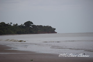
I found that this beach was fed by many small tributaries.  It is a very long expanse of sand, extending for miles from end to end.  From this beach you can see the northern drilling field of our marine oil company Trinmar a division of Petrotrin.  From what I remember, this northern field also was home to most of the compressor platforms.  I am saying what I remember as my father was head of the production department when he worked there and I myself worked for the company four years prior to me migrating to the USA.

The water at Granville was warm and a bit murky from the drilling and marine oil affairs taking place some 100 miles away.  The sky was overcast and the atmosphere breezy.  My brother and I walked up the beach and turned back just shy of the tip for fear of my camera getting wet with what looked like a fast approaching shower.

There were many buses and maxi taxis showing up at the beach facilities, with food and drinks in tow.  Seems like time to leave, because I do not like crowds.

Here are a few snaps showing the beach, the rigs, the chip chip, the tributaries, the vibe!


I hope that you enjoy.


© 2013, Odette M. Lawrence and NorDean Canvas. All rights reserved. The use and/or duplication of this material without the express and written permission of this blog’s author and/or owner are unauthorized and strictly prohibited.  

Friday, 12 July 2013

Manzanilla


A rural village located on the east coast of Trinidad, just a 20 minute drive north of Mayaro and less than a 30 minute drive south of Sangre Grande.

In 1942 during World War II, the area of Manzanilla became the temporary home of US soldiers.  This was as a direct result of a wartime agreement between British Prime Minister Sir Winston Churchill and US President Franklin Roosevelt.  During the six years of war a military training camp was established, soldiers who were assigned to the camp, trained in jungle warfare and were then dispatched to serve throughout the Caribbean.

The area was populated by disbanded soldiers who were expected to cultivate the land in cocoa, yam, cassava, rice and bananas.  The villagers were also commissioned by the government to build a 10 mile macadam (large stones) road from Sangre Grande to the Manzanilla beach.  Manzanilla was sectioned into three areas. Manzanilla one included the small village of Comparo, Manzanilla two included Cacao Wharf and Manzanilla three ended on the beach and included the fishing industry.

By the end of the 19th century, the area was booming with cocoa plantations, and inhabited by many squatters on government/crown land. 1886 brought the railway, however by then a good macadam road was already completed.

We found the drive to be short and uneventful.  The busiest time was going through Sangre Grande, else smooth sailing or should I say driving, out to Manzanilla.

At the beach I was confronted by an elder lady who wanted to know if I was already leaving.  She had a young lady visiting from Boston (and quite frankly I was wondering if she thought that I was the life guard).  I thought them an odd combination. Primarily because when speaking to the young lady, I did not hear any hint of Trinidadian and wondered how she came to be in the presence of an older lady who referred to her as a friend.  However, with chatty older folks the story often comes out with no prompting.  She told me that she met the young lady at the mango festival (a festival celebrated annually currently in its 5th year – by The Network of Rural Women Producers teamed with UWI and the Ministry of Food Production) which is hosted at the UWI field Station, Mount Hope.  (A little about the festival -- Sweet, juicy, versatile and delicious mangoes of every size and variety is the focus of Trinidad and Tobago’s fifth annual Mango Festival. It featured a mango market, mango products, grafting demonstrations, exhibitions, children’s activities, games, mango eating competitions and other entertainment, Trinidad and Tobago’s Mango Festival offers mango lovers every imaginable mango-made delight, from soaps and preserves, to candles and gift paper.  A highlight of the Festival is the mango market where a variety of the locally grown fruit can be purchased, including the sinfully sweet Julie, considered the Queen of mangoes, which was developed in Trinidad, as well as other varieties with whimsical names such as Rose, Hog, Calabash, Douxdoux, La Brea Gyul, Turpentine, and Graham – a seedling of the Julie mango. Trinidad and Tobago’s Mango Festival promotes economic opportunities through the sustainable use of the mango and educates participants on the many benefits of the much loved fruit).

I then found the young lady to be rather brave to meet a stranger at a festival and follow her home.  She told me that the young lady was a student at a university in Boston and was awarded a scholarship to go visit multicultural nations and study the diversity of the people and whether they live harmoniously or not.  The young lady first travelled to South Africa where she found that even though the culture was diverse, each nationality stayed to themselves, forming areas or villages of a particular race with not much intermingling.  She found that Trinidad showed a multitude of people living mixed with one another and even though we may have political strife, for the most part had no problems with our fellow man or neighbor.  She found a food so diverse and infused with each other’s seasonings that it was unique to the land.  She found that we had named the mixing of races, for example douglah: when one parent is East Indian and the other African. Another example CocoPyol: when one parent is African and the other Spanish, Portugese or French.  She documented us and was on her way back to present to her professor and class.

When we returned home, my husband showed me the older lady that accosted me on the beach in the local paper receiving an award at the mango festival for the best mango chow.  I then realized that the two must of met at the older lady’s stall.  

This beach was filled with sea shells, apparently there is a season for it, at one time the beach is littered with them and at others none to be seen for miles.  My husband, mother and daughter walked along the beach picking up sea shells for a later project.

It was a beautiful and relaxing day.  The beauty and peace of tranquility, the sunlight reflecting on water, the spray of salt in the air and coconut trees swaying in the breeze.  This is yet another chance to drive around our island to see, taste and smell, and as the locals say, “Welcome to Trinidad”.


© 2013, Odette M. Lawrence and NorDean Canvas. All rights reserved. The use and/or duplication of this material without the express and written permission of this blog’s author and/or owner are unauthorized and strictly prohibited. 

Wednesday, 10 July 2013

Toco


The North East most tip of the island, the area where the Caribbean Sea meets the Atlantic Ocean.  The point where you can stare as far as the horizon without the hint of land, making it look as though you’re alone in this world.  Even though the sister island of Tobago only lies 35 kilometers northeast of this point, you cannot see it from here.  Toco is the closest point from Trinidad to Tobago.

Yes the day started adventurous as we, having a week of schlepping our son to his science camp in the North Eastern town of D’Abadie, had nothing better to do with our time, than to tour the region and its beaches.  Our plan was not to bathe, but more to mark locations for later family visits.  So we travelled to local malls, shopping districts and yes, beaches where we have not been in over 20 years.  Today’s venture Toco, via Valencia.

The day started without an inkling of morning's promise, the mist, moist and tranquil with the notion of a shower, but alas the blaze of the sun showed its power over the other forces of nature.  A gentle kiss of the scent of tropical flowers, and fruit, yeah, it is the season of mangoes and they are everywhere.  The road long and winding, through many small villages, where you wonder if the natives travelled out much, as their lives proved to be a simple one.  Fishing, farming, owning a small shop of trinkets, or snackettes or a mini restaurant, seemed the order of business.  Then there was the occasional offering of a place to stay for a weekend, a week, etc.  Also of mention are the many bars along the route. 
 
We have befriended the smart phone app ‘waze’, and this app makes finding places so much easier as the streets of Trinidad and Tobago are installed.  The road surface is better than I expected.  Outside of the one area around the quarries where the heavy duty trucks are prevalent, everywhere else was smooth sailing.
 
In Toco there is a lighthouse which overlooks the Northeastern oceanic approach to the island.  This lighthouse built in 1897 is no longer in use, but it is a historic site and the grounds are well upkept.  This area is referred to as ‘Punta Galera’ (now Galera Point).  Galera is derived from the word ‘galea’, the name ‘Galeota Point’ (Galeota also derived from Galea) was given to the southeastern point of the island by Christopher Columbus, this name was accidentally given to the northern point as well and the name stuck.

In the old days there were no roads connecting Toco to the rest of the island, instead in 1818 Toco was accessed via the round island steamer service which was started by Governor Ralph Woodford.  This service allowed trade of goods and cocoa (one of the main products of the region).  The first roads were built to this area by 1930, linking the area to Sangre Grande.  Toco is the home of the 2012 Olympic Gold javelin winner Keshorn Walcott.

After our long almost two hour drive we have arrived.  We are greeted by many food vendors along the beach.  We chatted with one of the native “Sonia”, she had a welcoming and delightful personality.  She showed us an area that she referred to as the swimming pool, where the water was calm, and the waves broke further out to sea and the deepest area was lower than shoulder height.  We stood and soaked up the view of the coconut and local almond trees along the beach front.  Against our faces a gentle sea breeze, the waves lapping at the delight of the northeasterly trade winds, the beauty of God's creation for us all to see, smell, play in and digest.  The beauty of a small land, an island, southerly lying just above the coast of Venezuela, rich in natural resources with a diverse culture and people.  A land that I call ‘home’.


Road view of the ocean


  A beach along the way


Are we there yet?

On the way

The breeze

Calmness of Toco swimming pool

Different exposure of beach


Macro view of coral


Thought it was a nice cloud

Fishing village indeed


Lighthouse view


From the lighthouse, spray


These birds posed for me

Bridge only allowing one car at a time


© 2013, Odette M. Lawrence and NorDean Canvas. All rights reserved. The use and/or duplication of this material without the express and written permission of this blog’s author and/or owner are unauthorized and strictly prohibited.